Sunday, June 17, 2012

Dudhsagar, Waterfall.. GOA

The Dudh Sagar waterfall is situated in the Indian state of Goa in Sanguem taluka. It is located 60 kms from the capital city of Panaji and is well connected with Panjim and MargaoDudhsagar is even accessible through buses and taxis which can be taken from Panaji city.
through a rail and road network.
Perched on the lofty peaks of the Western Ghats, the Dudh Sagar waterfalls offer unrivalled beauty, and amazing scenery full of exquisite charms when in full flux after the monsoon showers. Like an idyllic Eden cradled luxuriously in the mountains, the Dudh Sagar waterfalls, which from a distance appear like milky streams, gradually climax into a gushing cascade as they come into full view of the onlookers.


Dudhsagar literally means ocean of milk. This is one of Goa’s most attractive and ideal picnic spots mainly offering charismatic natural beauty and amazing scenery when in full flow after the monsoons. The waterfall initially appears like streams of milk flowing down the mountain which later culminate into gushing cascades after they come in full view of the awestruck visitors. It is perched on the lofty heights of the Western Ghats and falls from a height of 603 meters. The celestial intervention in the origin of these waterfalls adds a mystic significance to Dudhsagar, almost like a dream come true. Even words are too less to describe this stupendous charisma of mythical fascination which is almost similar to a second Eden cradled luxuriously in the mountains.
If you were thinking that Goa is all about white sand and plenty of sea, think again! Very few tourisdestinations can offer the disparate experiences that Goa can. 

Dudhsagar-waterfalls 

When you have had your fill of the sea, it’s time to look ahead to the hills of the Western Ghats. The Dudhsagar Waterfalls is luxuriously enveloped in greenery and a breathtaking avalanche of milky white water. The word ‘dudhsagar’ literally means ‘ocean of milk’. The waterfalls are so named because of the white foamy water that comes down from a staggering height of 2000 feet above the sea level.
Dudhsagar Waterfalls are listed as one of the highest waterfalls in the world. They are the fifth highest waterfalls in India. The waterfall appears as if the streams of milk are flowing down from the mountains.


There is a myth associated with Dudh sager waterfalls. Years ago there lived a powerful and rich king on the top of a mountain in the Western Ghats along the Goan frontier. He lived in a lavish palace made of pure ivory and embedded by precious stones. Near this palace, there were luxuriant gardens abounding in a vast variety of flowers.

At one end of the forest, which fringed the king's palace, there was a picturesque lake. In the panoramic setting of this lake, the king's daughter, accompanied by her ladies-in-waiting, went to bathe and to sip sugared milk which one of her maids served to her in a pure gold jug.

One day, while she was sipping at the milk, a prince, who was passing by, stopped on hearing the sound of people nearby. Immediately, the princess poured the milk in the pond to shield her body from the glances of the stranger. It is believed that the sugared milk that was poured by the virtuous and modest princess still comes flowing down in torrents along that side of the mountain.

Dudh Sagar waterfalls with their strange, mystical fascination are a dream come true. The uneclipsed vision, furnished by this native waterfall as it plunges over crag-covered precipes and stupendous steeps, belies description.

The name of this waterfall evolves from the Konkani name for the falls, Dudhsagar meaning 'sea of milk'. This is because froth is formed due to the speedy surge of water from the majestic heights.
Inspite of being a perilous spot due to its slippery rocks, it is a popular site for trekking and hiking. The fall looks stunning post monsoon as it ripples with bubbling foam-like water.
The fall overlooks a steep, crescent-shaped edge of a valley covered with beautiful tropical forest. Monkeys, birds, bees, butterflies have carved their own niche amidst the flora of the region and the plunge pool abounds in aquatic life.
The Dudhsagar Falls is one of the most interesting falls of India and the largest and highest fall of Goa. Nearby is the Tamdi Surla Temple built by the Kadambas.
The road to this mighty fall is inaccessible during the monsoon season .The Goa Tourism Development Corporation (GTDC) runs tours to Dudhsagar on Saturday and Sunday from Panaji and Calangute. 
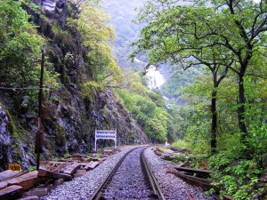
You could also take a train to Dudhsagar from Madgaon (Margao) and get there in an hour and half. However during summer, when the level of the water is low, you can hire a Jeep and access the foot of the falls from either Molem or Collem.
  
Dudhsagar waterfalls are located in the district of Sanguem in Goa. It lies at the distance of 60 km from Margao near the Goa Karnataka border. The falls take a steep plunge 2000 feet down in the wooden mountains of the western ghats. It originates high up on the river Mandovi’s watershed.
Flora and Fauna :


Dudhsagar waterfalls are the tourists hotspot because of its sylvan surroundings. The falls are located amidst the blissful tropical jungle. Lots of naughty monkeys can be spotted on the forests tress climbing, jumping and playing among themselves. Dudhsagar waterfalls is the popular birding site among the tourists. You can carry the binoculars along with yourself to indulge in bird watching. You may notice lots of species of butterflies and bees at this place. Apart from the birds and animals the region holds the rich aquatic life.
Other Attractions
While you are at the Dudhsagar Waterfalls, a visit to the Bhagwan Mahavir Wildlife Sanctuary can not be missed. It is the largest wildlife Sanctuary in India. The main attraction of the park are Royal Bengal Tigers, Barking deer, Blank Panther, bonnet macaque, common langur, civet, flying squirrel, gaur, leopards, mouse deer, pangolin, porcupine, sambar, spotted deer, wild boar and wild dog.

Swimming at Dudhsagar :
 
swimming at Dudhsagar 

Tourists can indulge in swimming in the pools created by the fall. Swimming at these pools is extremely delightful and safe too. The water is really climb. You can even try to climb the head of the falls through the bushes falling into the pools. During the monsoons the falls become much more lively and active. The natural beauty all around the Dudhsagar Waterfalls has also made it a popular picnic destination among the tourists.

Trekking at Dudhsagar :


Dudhsagar Waterfall is famed as the trekking destination. It is the trekkers paradise. Tourists are recommended to wear the comfortable clothes while trekking. It is good to carry the rainy coat along with yourself. The trek passes through the lush forests, giving you the opportunity to have encounter with the wilds. You can capture the beautiful sceneries of the environment in your camera. You will be fully entertained with the calls of the jungle. You can even feed the monkeys with the bananas on the way. Beware of the poisonous snakes on the treks which could be dangerous. Otherwise trekking here is quite a fun.

Accommodations:
There are not much options near Dudhsagar falls. There is a Forest rest-house, owned by KTDC, near the falls. Else visitors can stay at Margoa and plan a one day trip to Dudhsagar Falls.

Reaching there:
You can very easily reach Dudhsagar waterfalls by hiring a taxi or a bus from Panaji or Margao. The ideal time to visit the Dudhsagar waterfall lies after the monsoons, from the month of October till December. 
Dudhsagar Waterfalls- springing from from a lofty height of 600m is located on the Goa-Karnataka border. It lies at a distance of 60 km from Panaji and 10 km from Colem Railway Station.

Tuesday, June 12, 2012

Kuruvadweep, Wayanad, Kerala

Located about 17 kms east of Mananthavady in the northern district of Wayanad, Kuruvadweep is a group of islets forming 950 acres of evergreen forest. These islets are located in one of the tributaries of the River Kabani, which is close to the border with the State of Karnataka.


Kuruva Island is situated on the tributaries of the river Kabani and is a fabulous picnic spot. Its serene silence and wide expanse of the evergreen forest leaves you astonishing. This island is isolated but an array of uncommon species of birds, herbs and orchids are the monarchs of Kuruva Island.

Kuruva Dweep is a series of islands formed on the Kabini river in the Wayanad district of Kerala. Kabini is Tributary of Cauvery river. Dweep in Malayalam means island. The Kabini river splits in to two at the Kuruva Dweep and joins back again. With an area of 950 acres, Kuruva Dweep hosts a variety of plants and animals. Although much of the river is shallow in these islands , some regions are very deep. In those deep regions crocodiles can be found. Boating facility is provided here by the District Tourism Promotion Council of Wayanad.

Just 17 km to the east of Mananthavady, Kuruva Island is a vast island of 950 acres abundantly rich with green forest. It is very far from the turbulence of city life making it an exotic place for visitors to relax and enjoy the beauty of the nature. It is closed during monsoon (June to September). 

There are three prominent islets among the group, where one would come across a variety of vegetation, some rare orchids and wild flowers. One of these main islands contain two small fresh water lakes These islets are also haven for migratory birds, whose activities break the otherwise silent environs of these beautiful islets. The avian life here includes hornbills, parrots and a host of butterfly species.


Some of these islets have massive trees, the boughs of which at some places stoop down and caress the river water. The whole of Kuruvadweep has a unique Eco-system worth exploring for nature lovers. Those who venture into these islets needs to refrain from actions that would hamper the environment.

For those with a bent for trekking can make the most of it by heading for Kuruvadweep, while it is an exciting proposition for those carving for some blissful and serene moments; and for some it is definitely a place where one can get under the cool shades of big trees and listen to the lullaby of the gurgling river.


Getting there:
Kuruvadweep is 15 kms east of Mananthavady.
Nearest Railway Station: Kozhikode, about 106 kms away from Mananthavady.
Nearest Airport: Karipur Airport, about 129 kms from Mananthavady.

Friday, May 18, 2012

Parambikulam wildlife Sanctuary


Tucked away in the valley between the Anamalai ranges of Tamil Nadu and the Nelliampathy ranges of Kerala on the majestic Western Ghats is the Parambikulam Wildlife Sanctuary.This virgin valley that is the pride of Palakkad district is a glorious tribute to untouched nature.The reservoir harbours several varieties of aquatic fauna including mugger crocodiles that are often seen sunning on its banks.
Parambikulam Wildlife Sanctuary is the most protected ecological piece of Anamalai sub unit of Western Ghats, surrounded on all sides by protected areas and sanctuaries of Kerala and Tamil Nadu, the sanctuary is endowed with a peninsular flora and fauna which are excellently conserved due to total protection and minimal human interferences. 


The sanctuary being a major ecological continuum from Peechhi to Eravikulam through Anamalai aids the large viable populations of wildlife. It is the home ground for different races of indigenous people who are as well an integral part of the prevailing harmonious ecosystem. 
The thick, opulent habitat of the sanctuary with ample water supplys make it an abode for wildlife and there by for tourist who can have treasured memories of animal sightings and that of being in the lap of mother nature

Western Ghats is one of the world’s 34 bio diversity hotspots. While considering the abundance of Wildlife and the adorable beauty of Nature, Parambikulam Wildlife Sanctuary is perhaps the most attractive piece of wilderness in the entire stretch of Western Ghats. Thus it is popularly revered as ‘Nature’s own abode’. It has a total area of 285 Sq. Kms.


History

During the 19th century , the forests of Parambikulam were in two broad administrative units viz., Sungam Forest Reserve and Parambikulam Forest Reserve.


Porter, in 1886 wrote the first ever plan to manage the Sungam Forest Reserve. Heavy exploitation of forests for valuable timber started then. Teak planting began in Parambikulam during 1921 and in 1983 was the last plantation raised.
Sungam Forest Reserve was administratively the Sungam Range of erstwhile Nemmara Forest Division and Parambikulam Forest Reserve was the Parambikulam Range.
One of the major milestones was the introduction of the tram way in 1907. It was designed to exploit the forests and remove valuable timber to Chalakkudy wherefrom it could be transported by road. However, the Special Financial Committee abolished it in 1951.
Based on P.Narayanan Nair's plan, a special Teak Plantation Division was constituted from Parambikulam Forest Reserve in 1962. By then the Sungam Forest Reserve was declared as Parambikulam Wildlife Sanctuary (30 sq. miles) under the administrative control of State Wildlife Preservation Officer, Peermedu. Later in 1973, the Teak Plantation Division was dissolved and merged with the already notified sanctuary and a total area of 271 sq. km under the dual control of DFO, TP division and DFO, Nemmara.
In 1985, the sanctuary was administratively reorganized and it took the present shape and extent of 285 sq. km.


Highlights

 Area : 285 sq. km
 Location : Longitude:76º 35’- 76º 50’ E, Latititude:10º 20’ – 10º 26’ N

 Boundaries

 North : Nemmara Forest Division
 East : Tamil Nadu
 West : Chalakudy Forest Division
 South : Vazhachal Forest Division
Zonation

For effective management of the sanctuary, the area has been divided into three major zones viz., core zone, buffer zone and tourism zone. The  zones are  made based on the parameters such as biodiversity indices, improvement in vegetation profile and ease of management.
There are three zones  namely
  1. Core Zone
  2. Buffer Zone
  3. Toursism Zone


Core Zone
The objective of management of the core zone is to preserve it as undisturbed natural habitat.
Activities permitted
  1. Total protection against all forms of biotic interferences shall be ensured.
  2. Only scientific studies and research activities with proper sanction without destructive sampling techniques shall be permitted.
  3. Fuel wood collection and NWFP collection are prohibited.
Buffer Zone 
Buffer zone will be managed for improving the habitat with rigid protection and for restoring naturalness to the teak plantations so that they support better floral and faunal diversity. After achieving the desired level of diversity, the area shall be upgraded into core zone .
Activities permitted
  1. Improving natural regeneration status in the degraded natural moist deciduous and dry deciduous forests by augmentation.
  2. Meeting of Fuel wood requirements of local tribal population
  3. Collection of small quantities of NWFP for sustaining the the tribal hamlets.
Tourism Zone
This zone is to provide educative experience regarding nature and wildlife conservation to the discerning tourists. Also to provide livelihood opportunities to the dependent tribal communities through Ecotourism activities organized by local tribal community based Eco Development Committees.


Special Attractions

Kannimara Teak:


Kannimara teak is one of the largest living teak tree in the world. It has an amazing girth of 6.48m and a crown height of 48.75m It is believed to be around 400 years old.
According to the local tribal belief here when this tree was tried to cut down, the blood spurted out from the place of cut. This tree was being since then worshipped by the local tribes in Parambikulam as "Virgin tree". Thus the name Kannimara is given as the word ‘ Kanni’ means ‘Virgin’. This tree has been awarded ‘Mahavriksha Puraskar’ by the Government of India.


Salim Ali Bird Interpretation Centre:
The Salim Ali Bird interpretation centre at Kuriarty offers opurtunity for bird enthusiasts to learn and study the birds of Western Ghats in general.
The gallery provides a wonderful listing of birds ranging from common birds of india, birds of western ghats, birds of kerala and birds of parambikulam.


Shola Forests:


Shola forests are unique montane vegetation occupying temperate habitats in tropical latitude and are communities restricted to valley and depressions especially along the folds of hills. Karimala hills of this sanctuary has some resembling characteristics of this type. The forest restricted to Karimala hills, is not a true shola, according to forest type description, but it shows important characters of shola plants i.e., stunted short boled highly branched trees, clothed with mosses and other epiphytes. Woody climbers are few. There is no stratification for trees and leaves are mostly small.
         
Trees: Cinnamomum sulphuratum, Euonymus indicus, Ligustrum robustum (rox burghii), Mesua indica, Symplocos cochinchinensis, etc.

The species growing in this type of forests are given below.
Epiphytes (Orchids): Lycopodium phlegmaria, Bulbophyllum fusco-purpureum, Bulbophyllum tremulum, Eria clavicaulis, Eria reticulate, Oberonia denticulata, Oberonia lindleyana, Dendrobium chlorops, Dendrobium nutans, D.viridiflora etc.
Ground Vegetation:   Impatiens parasitica, Peperomia tetraphylla and other species of palatable grasses are in abundance.
One can witness this type of forests while trekking to the Karimala Gopuram through High Range Hiking  (Hard trek) package.


Dolmens (Muniyara):

Dolmens are the traditional cemeteries of tribal head men of Parambikulam Wildlife sanctuary. The Dolmens found in the forest of Parambikulam Sanctuary is believed to be 300 years old according the local tribes.
These Dolmens are beautifully erected with the help of flat stones and it is really an archeological marvel and traditional tribal heritage.
One can witness these traditional dolmens by undertaking dolmen trail package.


Location:
Chittur Taluk of Palakkad District. To reach the place one has to go to Pollachi via Coimbatore or Palakkad.
Altitude : 300 m to 1400 m above sea level.
How To Reach
By Road: The sanctury is only approached by the road. From Palakkad come along Kollangode, Govindapuram and cross TN border to Pollachi and deviate to Anamalai on Pollachi road, clear Sethumadai checkpost and proceed to Topslip which is the entrance to Parambikulam
By Rail: Palakkad (Olavakode-125km)
By Air: Coimbatore (100 km)

Tips for the discerning tourist:
Approach By RoadFrom Palakkad (Kerala) - 100 km
From Coimbatore (Tamil Nadu) - 84 km
From Pollachi (Tamil Nadu) - 38 km
Nearest Railway StationPalakkad (Kerala) - 100 km
Coimbatore (Tamil Nadu) - 84 km
Nearest Medical FacilityPrimary Health Centre, Parambikulam - 0 km
Private Poly Clinics, Vettaikaranputhur - 23 km
Nearest Fuel PumpVettaikaranputhur - 23 km
Bus Timings (TNSTC) 
From Pollachi6.15 am & - 3.15 pm
Parambikulam to Pollachi8.45 am & 5.45pm    
Pollachi to Topslip11.20 am
(distance between Topslip & Parambikulam Office Head Quarter – 4 Km)
Topslip to Pollachi1.00 pm


Contact:
Widelife Sanctuary Office, Parambikulam, Ph: 04253-245005
District Tourism Promotio Council, Palakkad, Ph: 0491-2538996

Tuesday, May 15, 2012

Paithalmala

                                   Paithalmala is an enchanting hill station in North Kerala (India), situated about 4,500 feet (1372metres) above sea level near the Kerala-Karnataka border and about 65 kms north-east of Kannur city and 44 kms away from Thaliparampu. It is an ideal spot for trekking as well. There are not many such enchanting hill stations in the region. These huge mountains lay spread over 500 acres of land enriched with dense forest. One can go by bus up to Kappimala. From there jeep can be driven for three kms. After that, 2 km walk by foot. North of Paithalmala is Kudaku forest. At the base of the mountain, a tourist information center and dormitory have been constructed.


Paithalmala ("Paithal" means infant and "mala" means Hill) (Malayalam: പൈതൽമല )is the one of the Mind Blowing Hill Station in the Kannur District (North Kerala). Some call it as "Vaithalmala". Which is situated in the Western Ghats near Kerala- karnataka Boarder. The nearest bus stop to the Paithalmala is Kudiyanmala, which is 43 Kms from Thaliparamba and 60 Kms from Kannur Railway Station. Paithalmala is 9 Kms far from Kudiyanmala. From Kudiyanmala upto 5 Kms tarred road is available and for adventures driving we will love that, because which contains sharp turnings with high slope. Paithalmala is located near to Kappimala village, at a height of 1371.6 m above sea level, this is the highest peak in Kannur.These mountain ranges extend to about 500 acres and are fully covered with dense forest. A wide variety of flora and fauna can be found here and the view of the valleys and mountains from here is breathtaking. Those tourists who wish to have an adventurous trip can come to this hill station. Some other attractions of this place include waterfalls and the wildlife. To reach at the grass covered hill station a 4 Kms walk through the forest is required, but is the hottest part of the travellers for trekking. That path is not that much smooth to cover. You need to cover these portions with salt water/ tea mixed water. Because a lot of Blood sucking leeches are the opponent there. They are jumping in to our leg by smelling the presence of human. So if we are washing our legs with the salt water,we can avoid them easly. Summer season is the best time for the visit to the paithalmala. On summer these leeches are not seen any where in paithalmala. The night sleep on a night in the top of paithalmala is a dream like event for all travellers those who are coming here. For that you can carry one small tent. Because of its height you can touch and feel the dreaming effect of mist here. The clouds will touch on your lips as like your friend. The area is surrounded by forest, but no cruel animals are not there in the paithalmala. 


Kudianmala (also spelt Kudiyanmala) is a village in the Western Ghats in India. It is one of the major centres of Syrian Christian migration (Malabar migration). The migration to this place started during the 1950s. Even before that there were inhabitants here. The name has a history behind it. The ruler of the Chirakkal Principality had a sister. She was accused of adultery. So, the ruler sent her and a set of servants to a place in Kudianmala with the name Kudiattivalappu, which is near Pottamplavu. After this, every 12 years Vyazhavattam, the ruler, used to send soldiers to kill the sons of the princess if any were born during this period. From this legend, the name Kudianmala was derived.Malabar Migration which initially started in 1920s and reached a peak in 1950s began changing the demography from 1950s. The Second World War created poverty in Travenocre and this caused the migration. Central Travencore especially Kottayam district was the focus of migration.In 1953 the Holy Mass was said for the first time in the history of this place. It is said that the name 'Paithal' has some connection with the 'Paithalkon' dynasty of Malabar.


                                   Tourism development in Paithalmala is being taken up as a major scheme by Government of Kerala. The works included the suspension bridge for watching the waterfall, renovation of the watch tower, facilities for camping, trekking path and road widening. The tourism development of Paithalmala is estimated at Rs.2.7 crores.
                                   Paithalmala is an enchanting hill station in North Kerala (India) in the Western Ghats near Kerala-Karnataka border. Standing as tall as about 4,500 feet (1372metres) above sea level, it is located about 65 kms north-east of Kannur city . North of Paithalmala is the Kudaku forest. These huge mountains are enriched with dense forest.Its best place for trekking. 


The peak offers a spectacular view of the surrounding mountains beneath it.. There are many seasonal waterfalls. Paithalmala is an ideal spot for adventure tourism as well. 


Location:

Nearest Railway Station: Kannur (60 Kms), Payyannur (62 Kms)
Nearest Airport: Calicut & Mangalore International Airports
Nearest Town: Kudiyanmala & Chemperi (Jeep is also available here)

Wednesday, April 4, 2012

Chinnar Wildlife Sanctuary, Kerala

The Chinnar Wildlife Sanctuary is located in the rain shadow region of Western Ghats of Kerala, India., and represents a large number of plants and animals unique to the thorny vegetation.

Apart from the dry thorn forests, due to the significant variation in altitude and rainfall, it has a wide array of habitat types like deciduous forests, dry thorny forest, riparian types, sholas and grasslands that are interspersed with plains, hillocks, rocks and cliffs which provide microhabitats for varied forms of life.
It is an abode of reptilian fauna and the richest in Kerala in terms of the number of species. Albizia lathamii, a critically endangered species has been reported from the dry forests of Chinnar. It is a well known repository of medicinal plants. The riverine forests along Chinnar and Pambar support a healthy population of Grizzled Giant Squirrel.
The famous ‘white bison of Manjampatti’ has been recently reported from Chinnar. With 225 species of birds, Chinnar is rich in avian diversity. In association with the neighbouring PAs, Chinnar forms part of a viable conservation unit.
A unique thorny scrub forest with xerophyte species, Chinnar is the habitat for the endangered Giant Grizzled Squirrel of India. Their total number here would be less than 200. Located in the rain shadow area of the Western Ghats, unlike other sanctuaries in Kerala, Chinnar gets only less than two months of rain every year. Rich in wildlife, the mixed deciduous forests here are ideal for trekking.
An extensive Sandalwood forest nearby is an added attraction at Chinnar. This is also an ideal place for watching herds of gaur and elephants amble past. Dry deciduous forests, high sholas and some grasslands add to the diversity of the sanctuary. As one travels from Karimuthi to Chinnar, elephants, spotted deer, sambar, hanuman langur and even peacocks can be spotted on either side of the road.


Location:
About 60 km from Munnar, Idukki district
Getting there:
Nearest railway station: Ernakulam about 130 km from Munnar. .
Nearest airport: Cochin International Airport, about 150 km from Munnar.

Friday, March 30, 2012

Gavi, Eco touism Project Pathanamthitta,Kerala

           Gavi Eco-Tourism a project of the Kerala Forest Development Corporation has caught the attention of tourists, mostly from European countries. The project is exclusive in many respects and the majority who visited was nature lovers and adventure tourists. Over a short period of time visitors to Gavi gradually increased, especially after 'Alistair International' the world acclaimed tourism major listed it among the leading eco-tourism centres and one of the must-see places in India.

           A highlight of the Gavi eco project is the involvement of the local populace in its activities as guides, gardeners and cooks. This will provide livelihood for the locals and also will help to create awareness on conservation of nature. Gavi, located in Pathanamthitta district offers its visitors activities like trekking, wildlife watching, outdoor camping in specially built tents, and night safaris.

           The road leading to the picturesque Gavi is blanketed by tea plantations, which itself is a refreshing experience. En route to Gavi are places of interest like Mundakayyam, Kuttikanam, Peermedu and Vandiperiyar from where the road deviates to Gavi.


           Once you reach Gavi the serene eco-lodge 'Green Mansion' awaits you like a fairy to embrace you in its protective fold. From the 'Green Mansion', one can savour the spectacular view of the Gavi Lake and the adjoining forests. Besides the accommodation provided in 'Green Mansion' visitors can also try out the tree houses here and can even pitch tents amidst the wilderness. Here one can have outstanding trekking experiences, which are overseen by trained local people. Those who would love to be left alone can do so in the tranquil environs of Gavi or may even go canoeing in the placid waters of the lake or enjoy a breathtaking sunset. Visitors are usually provided vegetarian food and snacks, which further adds to the eco-friendly ambiance of the place.

           The place is rich in flora and fauna. There are hills and valleys, tropical forests, sprawling grasslands, sholas, cascading waterfalls and cardamom plantations. Endangered species including the Nilgiri Tahr and Lion-tailed macaque are often sighted at the outskirts of Gavi. With more than 260 species of birds including the great pied hornbill, woodpecker, and kingfishers, Gavi is a heaven for birdwatchers.


            Some of the breathtaking viewpoints at Gavi like the Valley View offer spectacular view of a deep ravine and the forest below. From Kochu Pampa, a point near Green Mansion eco-lodge one can track the grazing Nilgiri Tahrs.

           The famous pilgrim destination, Sabarimala is a short trek from Gavi. For those interested in observing the nocturnal wildlife, night safaris to Kullur, Gavi Pullumedu, Kochu Pampa, Pachakanam provide ample opportunities for wildlife viewing.

           Another unique feature of Gavi is camping in the forests. One can pitch a tent in the camping site, which is a rarity in many Indian forests. As the dusk stretches into the silence of the night, one can feel the presence of wildlife in the middle of nowhere, an experience that cannot be explained in words. There are also tree top houses where one can enjoy the avian life to the fullest.

           Active involvement of tribals in Gavi makes it a unique venture of its kind in the country. Traditional knowledge of the forest and its way of life helps Gavi to sustain its surroundings in its original state. 
          Gavi is bound to cast its magical spell on every visitor and is surely a place that should not be missed in one's lifetime. Gavi is pristine, and it belongs to the wild, which is a reminder that visitors are responsible for their intentions and actions, which will have a bearing on the upkeep of Gavi for a long time to come.

Location:
Gavi is located about 28 km from Vandiperiyar, which is 18 km from Thekkady.
Nearest railway station: Kottayam, about 114 km away.
Nearest airports: Madurai Airport (Tamil Nadu), about 140 km away; Cochin International Airport, about 190 km away.

Contact AddressPeriyar Tiger Reserve.
Eco-Tourism Project Periyar.

For more details please contact:
Tourist Information Office
Department of Tourism, Thekkady
Phone: 04869-222620

Saturday, March 24, 2012

Mankayam falls


Close to the Capital City of Thiruvananthapuram is Mankayam, situated near Palode in Nedumangad Taluk. This water spectacle can be enjoyed at any time of the year. Mankayam was recently launched as a zone for ecotourism, managed by the State Forest Department.

At the Mankayam ecotourism zone, visitors can seek the assistance of guides with the entire activities coordinated by the Vanasamrakshna Samithi (Forest Protection Group), working under the forest department of the State.

Rising from the hill ranges of Chemunchi, the River Chittar, flowing down through the forests of Brymore creates a tributary in the form of Mankayam River. The Mankayam River in its course further down, produces two spectacular waterfalls. One is at Kalakayam, which is one of the biggest waterfalls in the area and the other at Kurissadi. The spectacular falls at Kalakayam and Kurisadi can be seen and enjoyed from view points provided by authorities. The Kurisadi Ghat offers an excellent spot for bathing.
With rich forest setting, the area in and around the waterfalls are overwhelmingly green. Shrubs to gigantic and lofty trees of evergreen and semi-evergreen grasslands are found here.
From Mankayam, visitors can go to nearby picturesque spots and can also go for trekking. An interior area trek here, covering Iruthala Moola - Ayampara is a half day trek, which also would enable one to witness the Ayampara waterfalls and some of the wildlife in the area. Adventure inclined visitors may opt for the one day Mankayam - Varayadin Mottai trek. This trek would take one through rolling valleys, grasslands and shola forests. You would also come across the endangered Nilgiri Tahr; a species of wild goat, at the peak of Varayadin Mottai. Camping options are available here along with trained guides.


Mankayam is situated at Idinjar Falls in Palode in Nedumangad Taluk of Thiruvananthapuram District. The Mankayam River, a tributary of Chittar, flows through this scenic tourist spot. Situated at an elevation of around 500 m above sea level, the fertile soil here has yielded lush foliage that houses interesting species of flora. The entire area from Mankayam to Kalakkayam covers a long stretch of forest vegetation on the banks of the Mankayam River. The undulating terrain with rocky patches shelters the Kalakkayam Waterfall, one of the biggest falls in this area.
Ecotourism Activities
Visits to picturesque spots and treks ranging from soft to hard adventure are possible here. The ecotourism zone extending from Mankayam to Kurisadi is about 1 km and covered with luxuriant vegetation of diverse forest types. Shrubs to gigantic and lofty trees of evergreen and semi-evergreen grasslands are found here. Just 20 m from the main road is the Kurisadi Ghat which is an excellent spot for bathing.
Kalakkayam-Kurisadi Falls
These delightful falls can be seen and enjoyed only from the view point provided with all security measures. Approach roads close to the waterfall is dangerous and visitors are not allowed to go near it.

Trekking TrailsThe following paths are excellent for soft, medium and adventure trekking.
Interior Area Treks - Iruthala Moola-Ayampara - a half day trek where visitors can see Ayampara Waterfalls and a variety of wildlife.
Adventure Trekking - Mankayam-Varayadin Mottai - one day trek taking in the panoramic view of rolling valleys, grasslands and shola forests. The Peak is famous for the Nilgiri tahr, the endangered species of wild goats. Camping facilities are provided at Varayadin Mottai in machans. Camp equipment, kits etc. will be arranged as also trained guides, to accompany the tourists during the tour

For enquiries and bookings,contact:
Divisional Forest Office, Thiruvananthapuram, Ph: 0471-2320637
District Tourism Promotion Council Office, Thiruvananthapuram Ph: 0471-2315397

Getting there
Nearest airport: Thiruvananthapuram International Airport, about 55 kms.
Nearest railway station: Thiruvanathapuram Central, about 45 kms.